
Drones Are the New Way to Reconstruct How Car Accidents Happen
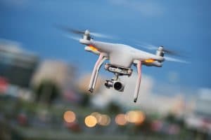 Auto reconstruction experts use a variety of methods to help show how a car, truck, or any type of vehicle crash occurred. They start by making a visual inspection of the accident site. They review police reports and the damaged cars. Many experts use computer graphics and other software programs to help show who caused the crash. Now, a new method is playing a major factor in traffic reconstruction analysis – drones. Lawyers, insurance companies, and law enforcement are all beginning to use drones to analyze how the accident happened.
According to UAV Coach, drones help reduce the “amount of time needed to collect a sufficient amount of data to map out the scene for an investigation.” Prior to the use of drones, reconstruction experts had to use pencils, tape measures, graph paper, and other tools to identify skid marks and the other relevant parts needed to reconstruct the cause of the accident. A full review could take six to eight hours – which often means reduced traffic at the accident site during those hours.
Laser scanners do help speed up the process, but even those tools can still require two to three hours for the accident review. Drones, according to Purdue University research, take just five to eight minutes. The time savings is just one benefit. Drones are also a better tool for conducting an effective investigation.
Drones also help provide the accuracy that is necessary to properly reconstruct the accident. A small mistake in the data can change the accident scenario, and who is responsible for the accident.
The Tippecanoe County Sheriff’s Office and Purdue University researchers (both in Indiana) are working together to study the use of drones for accident reconstructions. In 2018, the Tippecanoe Sheriff’s Office used drones to conduct accident reconstruction studies for 20 different accidents.
How does drone reconstruction work after a car crash?
The drone reconstruction process involves numerous steps. First, the drones collect visual data. Then, mapping software processes the data into 3D models, or “orthomosaic maps,” of the accident scene.
Why accident reconstruction with drones helps reduce accidents and keeps people safer
When police and any other first responders arrive at a car accident site, they have the following four objectives:
- Identify whether anyone is hurt. If someone is injured, they arrange for medical care such as calling an EMT service or an ambulance so the victim receives immediate attention and can be transported to an ER or burn facility.
- Ensure that the accident site is safe. The police need to make sure the cars don’t ignite and that nothing collapses or breaks.
- Ensure the integrity of evidence. Accident scenes can also be crime scenes, so it is critical that the evidence be kept secure, and that it is collected the right way. A problem with evidence collection can ruin a civil or criminal case. This is especially important, because those same drones help to….
- Clear the site of the wreck. Usually, the main highway task is to arrange to move the damaged vehicles off the highway and redirect traffic until the accident site is clear. The more time it takes to clear the site, the increased likelihood another accident may occur as vehicles steer around the accident, while also looking at the accident damage instead of the traffic in front of them.
The third and fourth priorities are somewhat in conflict since moving the vehicles and clearing the accident site can affect the evidence needed to assess how the crash occurred. For this reason, the quicker evidence can be collected, the sooner the vehicles can be moved – which, in turn, reduces the danger of a “secondary accident.” Often, cars will get into these additional accidents because they stop suddenly, they (or other cars) shift lanes, and the other cars run into or over debris such as broken glass from the initial accident. “The likelihood of a secondary crash increases by 3% for every minute the primary incident is ongoing…. According to data from Purdue University, secondary crashes go up by a factor of 24 right after a crash.”
By speeding up the evidence collection process, drones help clear the roads faster which means fewer secondary accidents. Using drones for accident reconstruction makes the roads safer in another way. The fast response means the first responders themselves are less likely to be injured in a subsequent crash. First responders need to get off the road as quickly as possible – even when the area is marked off.
Who is using drones for accident reconstruction?
While police are currently a major driver of drone use, others are using drones to conduct accident reconstruction investigations, too:
- Personal injury lawyers are starting to use drones for several reasons. The first is that the drones help provide a more reliable analysis of how the accident happened and who’s responsible. The drones also help create better accident maps. The drones also help persuade juries because the drone usage and the maps make for great visuals.
- Insurance companies are also using drones to analyze how car accidents and other types of accidents happen.
Data from the accidents based on drone usage may also help provide better long-term data that can be used for better roadway design and maintenance.
Car accidents happen for many reasons. The way an accident occurred often indicates who was at fault. When accidents happen, you need seasoned Oklahoma City car accident lawyers on your side. At Cunningham & Mears, our wrongful death and personal injury lawyers file claims against all responsible parties. We demand compensation for your pain and suffering, medical bills, lost income, property damage, and other damages. Call us at (405) 232-1212, or complete the contact form to schedule a free consultation today.
Ryan Y. Cunningham is a founding partner of Cunningham & Mears. Mr. Cunningham devotes his practice to protecting the rights of injured Oklahoma residents. In addition to assisting injured clients, Mr. Cunningham endeavors to improve personal injury representation by speaking on issues related to personal injury law to attorneys in continuing legal education courses and to law students. Learn More